
SIM Ensures Accurate Subsurface Investigations

- · The SIM standard specifies that a professional utility locating contractor must use multiple complementary locating technologies
· These include ground penetrating radar (GPR) and electromagnetic (EM) locating
· Utilizing multiple technologies capitalizes on each tool’s strengths – creating a redundant confirmation when designating subsurface elements

· The national standard for certification (ASNT SNT-TC-1A) states that a minimum of eight hours of classroom training and 60 hours of practical application coaching is needed to be certified as NDT Level 1
· To achieve SIM certification, an operator must complete a minimum of 320 hours of mentored field training and 80 hours of classroom training

· When evaluating professional utility locators, the right training and the best tools are only part of the equation
· SIM addresses a step-by-step approach to collecting subsurface data to ensure that the results are repeatable and accurate
· SIM practitioners must follow a checklist designed to ensure optimal results for every situation encountered in the field
Subsurface Investigation Methodology, or SIM, was developed to provide greater education, advanced field training, and a repeatable process for accurately locating utilities and other subsurface infrastructure.
SIM is a guide to using locating technologies such as ground penetrating radar (GPR) and electromagnetic (EM) locating, combined with a proven training approach, to achieve a high rate of locating accuracy. SIM does not involve the practice of geophysics, geology, land surveying, or engineering.
Experience-based training ensures your utility locator is ready to tackle the unique challenges of your job site.
Using multiple utility locating tools to compensate for each tools’ individual limitations.
3. The Applied Methods & Practices Asset
Combining the experienced technician with the best technologies available to ensure a successful project.
Why Does It Matter?
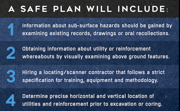
Subsurface damage is a very real, very serious threat to the communities you work in, your workers, your budget, and your schedule. But most – if not all – of the losses attributed to striking buried utilities or other underground infrastructure can be avoided through a detailed site investigation that employs multiple technologies applied by highly trained personnel.
Your first step for mitigating the risk of subsurface damage is contacting your local 811/One Call service.
811 is the national, not for-profit notification service that acts as a link between excavators and contractors, and participating member utility companies. Federal law requires that 811 be notified of upcoming excavation projects, so they can in turn notify the utility companies who send representatives to the site to mark their utilities with flags or paint.
While 811 is your first step toward ensuring a safe excavation, it’s important to remember that utility companies are not responsible for marking out private lines on a property they visit – only their own public utilities.
That’s why you should also always hire a professional, SIM-certified private utility locating company to locate and map all buried utilities in your intended dig area before you put a shovel or bucket in the ground or saw or drill into a concrete slab.
These companies use tools such as GPR scanning and EM locating to locate and map underground utilities and scan concrete slabs to identify the layout of rebar, post tension cable, and more.
While the technology for underground utility locating and non-destructive concrete imaging is fairly standardized today, the methods of deploying these tools is not. SIM ensures the precision and attention to detail necessary for the accurate subsurface investigations that will keep your projects on time, on budget, and safe.
This is why SIM was developed: to provide greater education, advanced field training, and a repeatable process that accurately locates utilities and other subsurface infrastructure.
Purpose:
The purpose of the SIM Specification is to quantify the components that form the SIM process. Universal adoption of the methods and applied technology strategies used during the typical subsurface investigation will yield higher quality results for the end client and lower hit rates for the contractor. The scope of this paper is limited to the private property underground utility location market and the location of critical embedments in concrete.